Nicholas Hedges

Art, Writing and Research

  • Amazon
  • Behance
  • Facebook
  • Instagram
  • Pinterest
  • YouTube
  • Art
    • Digital
    • Drawing
    • Grids
      • Correspondence
      • The Wall
      • The Tourist
    • Ink on paper
      • Shadow Calligraphy
    • Installation
      • Murder
      • Echo
    • Painting
    • Patterns
    • Mixed Media
    • Photographic installation
      • St. Giles Fair 1908
      • Cornmarket 1907
      • Headington Hill 1903
      • Queen Street 1897
    • Research/Sketches
    • Stitched Work
      • Missded 1
      • Missded 2
      • Missded 3
      • Missded 4
    • Text Work
  • Blogs
    • Family History
    • Goethean Observations
    • Grief
    • Light Slowed But Never Stilled
    • Lists
    • Present Empathy
    • Shadow Calligraphy
    • Trees
    • Time
    • Walking Meditations
  • Video
  • Photography
    • Pillars of Snow
    • Creatures
    • The Trees
    • Snow
    • St. Giles Fair 1908
    • Cornmarket 1907
    • Headington Hill 1903
    • Queen Street 1897
    • Travel
  • Illustration and Design
  • Music
  • Projects
    • Dissonance and Rhyme
    • Design for an Heirloom
    • Backdrops
    • Shadow Calligraphy
  • Exhibitions
    • A Line Drawn in Water
      • Artwork
    • A Line Drawn in Water (Blog)
    • Mine the Mountain 3
      • Artwork
    • Mine the Mountain 2
      • Artwork
      • The Wall
    • The Woods, Breathing
      • Artwork
    • Snow
      • Artwork
    • Echo
      • Artwork
    • Murder
      • Artwork
    • The Tourist
    • Dreamcatcher
    • Mine the Mountain
      • Artwork
      • The Tourist
    • M8
    • The Gate
    • Creatures
      • Artwork
    • Residue
      • Artwork
    • A visit to Auschwitz
      • Artwork
  • Me
    • Artist’s Statement

The Narrative Line

June 24, 2010 by Nicholas Hedges

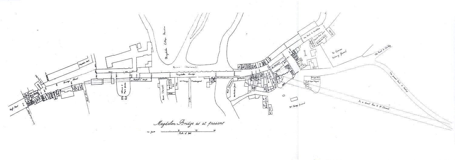
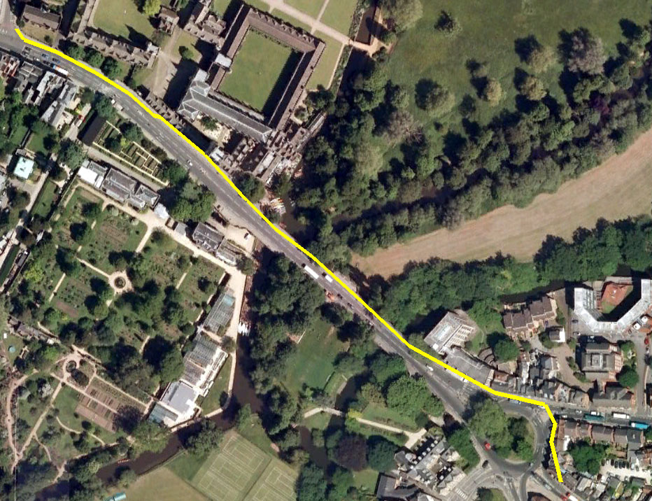
With my GPS, I traced the route we know the Gentleman’s Servant took across Magdalen Bridge up into modern day Cowley Road.  It was hard to imagine the scene in 1770 when the road would have been much quieter. Cars, buses and motorbikes were everywhere, the sound of their engines blocking out almost everything else.

But nevertheless, as I walked, I tried to take in everything around me, to capture all that made the present moment what it was, for even though the same place in 2010 is light years away from what it was 240 years ago, nevertheless, when the stranger rode over the bridge on December 12th 1770, it was something which for him was happening in the present. Now this might sound an obvious thing to say, but often when we read about the past, it’s almost as if we’re reading a fiction – a story which has a beginning, a middle and an end, and in which the characters follow a proscribed route laid down by the author: the narrative line in this instance comprises the text which makes up the tale. Of course life isn’t like this. When we walk, even if we’re going somewhere particular, we walk without knowing what may lie ahead of us. We might well know where we’re going, but how we’ll get there exactly, and what will happen as we travel, is something we only discover in the present moment.

As I wrote as part of a recent exhibition:

The Past is Time without a ticking clock. A place where paths and roads are measured in years. The Present is a place where the clock ticks but always only for a second. Where, upon those same paths and roads we continue, for that second, with our existence.

I want to read history in terms of its seconds – the small spaces within which life really happens. Every second in the present day – every moment – is a lens through which we can glimpse the past, no matter how distant it is. The more we know about the past (in particular the ‘geography’ of whatever we’re researching) the better the picture. But something in the space of every second reminds us, that what happened in the past happened in what was then a present just like ours; something as a simple, for example, as trees blowing in the wind.

The narrative line is like a piece of text; we follow it as we follow the words of a sentence, putting one foot in front of the other. But reading between the lines, we fill the gaps with what we see and experience around us. We are reminded that the stranger was moving all those years ago, unaware of what might lay before him. We become aware that he could feel the wind on his face, that he could see the sky, the river flowing beneath the bridge. And as we think, we realise that he himself was thinking, as was everyone around him – and this is the key to answering the questions I posed at the beginning of this project.

Every second the stranger rode along that line, he was part of a complex web of connections. These moments comprising his story were moments in many others – countless stories in a plot more complex that we can  imagine. The more we know about these moments, the more we can picture the scene and all who lived at the time, the better the chance we have of finding answers.

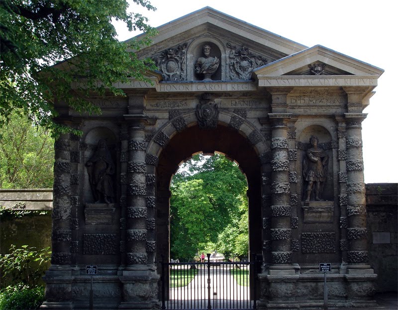
As I walked the length of the line, I looked to my right and glimpsed the 17th century gateway to the Botanic Gardens, and in that gesture, I found a connection with the stranger. The gateway is a witness to the moment I’m researching, and looking at it is one way of asking it for an answer.

Filed Under: Oxford, The Gentleman's Servant, Trees Tagged With: Gentlemans Servant, GPS, Lines, Maps, Oxford, Positioning, Servant, Survey, The Gentleman's Servant

John Gwynn’s Survey 1772 – Pt 2

June 24, 2010 by Nicholas Hedges

Whilst looking through some old research I did a few years ago, I came across the drawing reproduced below of Magdalen Bridge and its environs taken from John Gwynn’s survey of 1772.

It shows the route we know the stranger took – the narrative line of this story – on December 12th 1770 along with the names of those who lived or owned properties bordering the street in 1771/72. Interestingly, my namesake – at least as far as my surname goes – owned property just in front of the old church of St. Clement which was demolished in 1828.

Filed Under: Oxford, The Gentleman's Servant Tagged With: John Gwynne, Maps, Oxford, Survey

John Gwynn’s Survey 1772

June 23, 2010 by Nicholas Hedges

Remarkable evidence of those who lived in Oxford around the time the notice appeared in Jackson’s Oxford Journal can be found in a survey carried out by John Gwynn in 1772 (John Gwynn also designed the new Magdalen Bridge). Made as part of continuing improvements originating with the Mileways Act of 1771, the actions of Gwynn (who could be seen around town measuring the fronts of houses and other buildings) aroused suspicion and even alarm among the city’s residents. The survey itself was required to calculate the costs of repaving the city’s streets for which each property was liable to pay a share depending on the size of their facades. What we have as a result is a wonderful record; a long list of names of all the city’s residents (or rather property owners), the streets on which they lived (or owned property) and the size of their dwellings – given in yards, feet and inches. It’s interesting for me that among the many Stevenses listed in the survey might well be my great-great-great-great-great-grandparents.

The page reproduced below, is taken from the survey and represents the bottom end of the High Street where it meets Magdalen Bridge – the Bridge can be seen listed below the name of a Dr. Sibthorpe. The Physick Garden above, is the old name for what is now the Botanic Gardens.

See also John Gwynn’s Survey 1772 – Part 2.

Filed Under: Oxford, The Gentleman's Servant Tagged With: 18th Century, John Gwynne, John Malchair, Oxford, Survey, The Gentleman's Servant

Mr Stevens

August 11, 2009 by Nicholas Hedges

A year or so ago, I started work on a piece of work based around John Gwynn’s survey of 1772. The piece was called (as a working title) ‘6 Yards 0 Feet 6 inches’ based on the measurement of John Malchair‘s home in Broad Street. Having discovered an ancestor – John Stevens – born in the city in 1811, I wondered if there was any chance that one of the Mr Stevens’ listed on the survey was an ancestor of mine? It seemed a long shot but after today’s research I’m rather more optimistic.

If I did have an ancestor in Oxford at the time of the survey and if my research is correct, then that ancestor would be John Steven, the grandfather of the one previously mentioned. I’ve no idea when he was born but I do know that he was married in 1764 and is described as coming from St. Martin’s Parish, where his son Samuel, John Jr’s father was baptised in 1776. One could assume therefore that I did indeed have ancestors living in the parish of St. Martin’s at the time of the survey.
The images below are taken from the survey and show two Stevens one of which might well be my ancestor.

Gwynn fails to include (at least on the copy I have) first names from the survey but within the parish of St Martin’s two Mr Stevens are recorded along with a Mrs Stevens. One can assume however, that those most likely to be mine are the two Mr Stevens mentioned as living in the parish, one in Butcherrow (now Queen Street), the other in North Gate Street (now Cornmarket). The residence in Butcherrow is 7 yards 0 feet and 6 inches. That in North Gate Street is 4 yards 2 feet 0 inches.

John Gwynn's Survey 1772

John Gwynn's Survey 1772

Of course more work is required to see if one of these is indeed my ancestor, but I must admit to being very inspired by the prospect.

Filed Under: Oxford Tagged With: 18th Century, Family History, Family Stevens, John Gwynne, Oxford, Stevens, Survey

Abingdon Road

September 1, 2008 by Nicholas Hedges

One of my favourite drawings is that made by a German-born, Oxford-based artist called John Malchair, who lived and worked in the city in the late 18th century. The drawing shows a view of the Abingdon Road as it appeared in 1770 with the strange and imposing edifice of Roger Bacon’s study in the foreground – a building that was demolished nine years later – and the familiar, extant structure of Christ Church College’s Tom Tower behind.

There’s something beguiling about the image, depicting as it does the city long before the car, before its expansion into the suburbs when still surrounded by fields and meadows. It’s a quiet almost pastoral scene in which I feel I can hear the birds and feel the sun on my face. I can almost hear the quietude, contrasting it with the sounds I would hear today if I stood in a similar position; indeed, it’s an image in which I am constantly contrasting, moving back, to and fro between the past and the present.

This contrast between the past and present is what I experience as I research my family tree and this image I’ve lately realised embodies some of my recent thinking and research. My great-great-great-great-grandfather, Samuel Stevens, born in 1776, lived and worked as a tailor on St. Aldates in Oxford, a street which is in effect a continuation of Abingdon Road as it moves towards and connects with Carfax in the city centre. I like the fact that he is contemporary with this image and would have been alive (if only a small boy) when Roger Bacon’s study was still standing.

On the other side of my family tree, on my father’s side, my great-great-great-great-great-grandfather, William Hedges lived and worked in Abingdon, a town in which his line lived until George Hedges moved to Oxford sometime around 1869 when he married Amelia Noon, daughter of Charlotte Noon, murdered by her husband Elijah in 1852 (see ‘A Murder in Jericho‘). It’s very likely of course that both these lines (the Stevens’ and the Hedges’) continued back in those same places (Oxford and Abingdon) for further generations, and I like the fact that in this image by Malchair, and in a sense in the building he drew, is a connection between the two. Not only that, there is a connection between my past and my present, as if that connection might be found in the road between Oxford and Abingdon.

Finally, in a project I started some time ago (6 Yards 0 Feet 6 Inches) I make mention of a survey by John Gwynn, carried out in 1771 in which all the residents of Oxford are listed along with the measurements of their properties. It’s a fascinating document in its own right, but if Samuel Stevens’ parents lived in Oxford just a few years before his birth, they would be listed in that survey. Flicking through there are a number of Stevens’ and I can’t help but think one of them is my ancestor.

Filed Under: Oxford Tagged With: 18th Century, Drawings, John Gwynne, John Malchair, Oxford, Survey

Oxford’s Lost Streets

April 8, 2008 by Nicholas Hedges

Appropriately for the work I’ve been doing on Oxford Destroyed (itself, part of my Tour Stories project), I chanced again upon a map of the lost streets of Oxford. I first found it a year or so ago, and it was only in conversation today that I remembered it; strange how things acquire relevance at a much later date. The map shows a number of streets and lanes lost to the city by the 17th century; among them Exeter Lane, Schools Street, Frideswide Lane and Jury Lane (the rather unfortunate Shitbarn Lane was also amongst their number). Looking at the map, I couldn’t help think of the ‘map’ I’ve recently ‘made’ as part of the the Oxford Destroyed project; the aerial view of the fictional ruined city.

Oxford Ruins

Thinking about the ruined cityscape, I imagined as I ‘walked the ruins’, how the layout of the streets would perhaps change as new routes were cut through the rubble of buildings, and, looking at the map of the lost streets of Oxford along with those which are still in existence, one can see how these changes are in fact all part of the natural evolution of the city.
In my introdction to Tour Stories I wrote:

As old as it is, Oxford is like every city, one which constantly changes. People come and go, passing through its streets as daytrippers; others live a lifetime here and never leave. Generations come and go, stones corrode; whole buildings are lost to progress. Every day the city is in some small way renewed, restored, destroyed and rebuilt. And with every building that is lost, with the death of every one who has ever known it, so the city changes.

The one thing that has changed little over the centuries is the layout of the streets. Buildings as I said above are lost to progress; generations come and go. One of the things that defines Oxford as being what it is is this ancient layout of streets and lanes down which people have walked for hundreds of years. But nevertheless as the map has shown, even these streets can be removed. High Street, Queen Street, St. Aldates and Cornmarket Street might well have stayed more or less intact (albeit the last three with different names) but those such as I listed above have succumbed.

The idea of streets lost to time beneath various buildings is to me as enigmantic as the lost names of John Gwynn’s survey (1772), a document I have been using on another project; 6 Yards 0 Feet 6 Inches and just as I am exploring this survey through a piece of sonic art/composition, so I want to explore these missing thoroughfares. The spaces still exist of course; Jury Lane has been swallowed up by Christ Church, Exeter Lane by the Bodleian Library, Schools Street by Radcliffe Square (part of it is still extant and is now known as St. Mary’s passage) and Frideswide Lane also by Christ Church.

The lost streets also interest me in relation to other projects; for example, the route between the two sites for my Mine the Mountain exhibition in Autumn (the Town Hall Gallery and the Botanic Gardens) are connected by Deadman’s Walk, the route taken along the old city wall by Jewish mourners in the 13th century. It seems to me that some of that route was along what its shown on the map as being Frideswide Lane, but what interests me in particular is Jury Lane off what is now St. Aldates. In the Victoria County History for Oxfordshire, it states :

Jury Lane (c. 1215-25): Little Jewry (1325); Jury Lane (1376); Civil School Lane (1526). Closed c. 1545 and incorporated in Christ Church.

Little Jewry corresponds with Great Jewry, the old name for St. Aldates which was, after Great Jewry, known as Fish Street. It was the mediaeval Jewish Quarter and the missing street strikes a chord with the theme I have been exploring for the past eighteen months or so; the missing of the Holocaust.

This theme of missing people has lately found form in another project – Umbilical Light and seeing the faces in this work, it is interesting to see how all these works are becoming intertwined.

Filed Under: Oxford Tagged With: History, John Gwynne, Lost Streets, Oxford, Survey

6 Yards 0 Feet 6 Inches III

April 6, 2008 by Nicholas Hedges

Following up the work I have done so far with the composition based on John Gwynn’s survey, I have decided to do the same with video. This follows on from work I have done on Tour Stories/Umbilical Light, projects based on photographs taken in Oxford around the turn of the 19th/20th century.

I’m not sure yet what the images will be within each, but I think it will be something along the lines of the photographs I have been using.

Filed Under: Uncategorized Tagged With: 18th Century, 6 Yards 0 Feet 6 Inches, John Gwynne, Sonic Work, Survey

6 Yards 0 Feet 6 Inches II

April 2, 2008 by Nicholas Hedges

Having converted the distances for each dwelling/building into seconds, I created a new track in Cubase and added markers for each of the sections, creating as a result a sonic image for the southern side of the High Street as it appeared in 1772. Below is a detail of a larger screenshot. Click on the image to open a new window with the larger image.

I’m not sure at this stage how I will proceed with the score, but I have added a note (C3) at each marker point which is at least a start. These can be seen in the two midi tracks beneath; the first track a short note, the second row the length of the interval between them. Listening – whilst it doesn’t make for an interesting sonic encounter – does at least allow the listener, in this case me, to get a sense of physical space of the street from the duration of the notes (in the case of the second midi track) or the duration between each (as in the case of the first).

Filed Under: Uncategorized Tagged With: 18th Century, 6 Yards 0 Feet 6 Inches, John Gwynne, Sonic Work, Survey

6 Yards 0 Feet 6 Inches

March 22, 2008 by Nicholas Hedges

I’ve started to consider ways in which I might use John Gwynn’s survey of 1772 as a basis for a score and after various ideas decided the best place to start was – obviously – with the measurements Gwynn recorded; measurements of the size of properties in the centre of the city.

The following is an image taken from a reproduction of the survey, showing Gwynn’s statistics of 1772, and those taken in 1911 for Holywell Street.

For the moment I have decided to concentrate on the south side of the High Street and have reproduced the stats for this part of the city which can be downloaded as a PDF. After various attempts at translating the measurements into time so that the score might be structured in this way, I finally came up with the following method: the yards and feet I converted into inches (36 inches in a yard, 12 inches in a foot). I added the remaining inches and then converted back into yards (the idea was to end up with a figure or figures that most resembled time, e.g. 10.789 seconds). So for example; Mr Brockis owned property on the south side of the High Street which was 14 yards, 2 feet and 4 inches in length. By using the wonders of Excel, I ended up with a figure – through calculating with the above formula – of 14.77777778 yards, which although was more like the period-of-time-type measurement I was looking for made me feel uneasy; there was something about decimal points and imperial measurements which didn’t add up so to speak. The obvious thing therefore was to convert this sum (14.77777778 yards) into centimetres, which in another column of my ever-expanding spreadhseet I did by multiplying the sum by a factor of 91.44. Mr Brockis’ propery therefore came out as being 1351.28cm in length, or 13.5128 metres. Much better; I had my figure.

The next thing to do was to take these seconds and see how long the composition for the south side of the High Street would be. Again using Excel, I calculated that the entire piece would last 13 minutes and 32 seconds and today I decided to try it out. Armed with a stopwatch I walked the length of the street (in quite appalling weather) and found that at a reasonable, ambling kind of pace, it took me about 10 minutes 25 seconds. Although not quite 13 minutes 32 seconds (others would of course walk much more slowly) it nonetheless means that any following composition is imbued with a sense of space; the music (whatever the music will come to be) will liaise directly with a walk through the city.

Filed Under: Uncategorized Tagged With: 18th Century, John Gwynne, Survey

John Gwynn Survey

March 3, 2008 by Nicholas Hedges

I have for a long time been interested in John Gwynn’s survey of 1772, carried out in reponse to the Paving Commission’s desire for improvements to the city. In ‘A History of the County of Oxford: Volume 4’ (Victoria County History), it states in the opening paragraph on ‘Modern Oxford’ that ‘…With the Paving Commission of 1771 Oxford’s modern history began…’ and that ‘…The enthusiasm for public improvements alarmed some householders, particularly when the Paving Commission’s surveyor, John Gwynn, was observed all over town, measuring and making notes on streets and houses.’

For a long time I have wanted to work with the survey, being particularly interested in the list of names and associated measurements of the spaces they occupied in the eighteenth century city; people who of course have long since disappeared.

I had looked at it in relation to some work I did as part of my residency at OVADA in April/May last year. Firstly, regards a painting called Gloucester Green to Broken Hayes:

The title ‘Broken Hayes’ is the old name for Gloucester Green and describes a place which, in a sense, no longer exists, although, like the ghostly dwellings on John Gwynn’s survey (1772) it’s ‘footprint’ is still visible in the boundaries of the Green. Many of the items rubbed out on the canvas no longer exist in the places where I ‘found’ them; they are, in name only memories, just like Broken Hayes, yet like the physical aspect of that place, they still exist.

Then the walk I made from which the painting derived:

This isn’t an area I know that well – I’m not sure if I’ve ever walked the entire length of Paradise Street – and yet afterwards, when I looked at David Loggan’s map of 1675, it all seemed very familiar. I was surprised at how much was left after the upheaval of redevelopment, particularly when standing near St. George’s tower, near the junction of St. Thomas’ and Paradise Streets. Now, looking at John Gwynn’s surveys, I could make much more sense of the Oxford of 1772.

In another entry I wrote:

“But the layout of the streets (if not the buildings and their inhabitants) still remain, and so, by walking these streets, armed with a residual list of measurements, one can walk back in time and make a connection with this vanished population.This correlation between time and distance had initially come through my thinking of how difficult it often is, to identify with people who live abroad in war-zones (Iraq and Afghanistan for example), for, even though these countries are only a comparatively short distance away, they might as well be years in the past, for it’s almost as difficult to relate to those who live (and die) there, as it is to those who lived and died, for example, during the first and second world wars, or the time of John Gwynn.”

However, in light of the recent work I have made as part of the Brookes show at MAO, my ideas have changed a little. Thinking back to some thoughts I had on the Three Fates, I’ve decided to try merging the two ideas. One aspect of the story of Gwynn I liked particularly was the idea of residents being worried by his measuring, as if he was measuring up the fate of their homes and the city as a whole. So, I’ve decided to take these measurements, and using string and a ruler, measure out the string and cut them according to the survey. Mr Pepal would therefore be 12 yards, 1 foot and 9 inches.

Filed Under: Oxford Tagged With: 18th Century, John Gwynne, Oxford, Survey

© Nicholas Hedges 2024

  • Facebook
  • Instagram
  • Twitter
  • YouTube

Copyright © 2025 · Outreach Pro on Genesis Framework · WordPress · Log in