Nicholas Hedges

Art, Writing and Research

  • Amazon
  • Behance
  • Facebook
  • Instagram
  • Pinterest
  • YouTube
  • Art
    • Digital
    • Drawing
    • Grids
      • Correspondence
      • The Wall
      • The Tourist
    • Ink on paper
      • Shadow Calligraphy
    • Installation
      • Murder
      • Echo
    • Painting
    • Patterns
    • Mixed Media
    • Photographic installation
      • St. Giles Fair 1908
      • Cornmarket 1907
      • Headington Hill 1903
      • Queen Street 1897
    • Research/Sketches
    • Stitched Work
      • Missded 1
      • Missded 2
      • Missded 3
      • Missded 4
    • Text Work
  • Blogs
    • Family History
    • Goethean Observations
    • Grief
    • Light Slowed But Never Stilled
    • Lists
    • Present Empathy
    • Shadow Calligraphy
    • Trees
    • Time
    • Walking Meditations
  • Video
  • Photography
    • Pillars of Snow
    • Creatures
    • The Trees
    • Snow
    • St. Giles Fair 1908
    • Cornmarket 1907
    • Headington Hill 1903
    • Queen Street 1897
    • Travel
  • Illustration and Design
  • Music
  • Projects
    • Dissonance and Rhyme
    • Design for an Heirloom
    • Backdrops
    • Shadow Calligraphy
  • Exhibitions
    • A Line Drawn in Water
      • Artwork
    • A Line Drawn in Water (Blog)
    • Mine the Mountain 3
      • Artwork
    • Mine the Mountain 2
      • Artwork
      • The Wall
    • The Woods, Breathing
      • Artwork
    • Snow
      • Artwork
    • Echo
      • Artwork
    • Murder
      • Artwork
    • The Tourist
    • Dreamcatcher
    • Mine the Mountain
      • Artwork
      • The Tourist
    • M8
    • The Gate
    • Creatures
      • Artwork
    • Residue
      • Artwork
    • A visit to Auschwitz
      • Artwork
  • Me
    • Artist’s Statement

Thoughts so far

November 3, 2010 by Nicholas Hedges

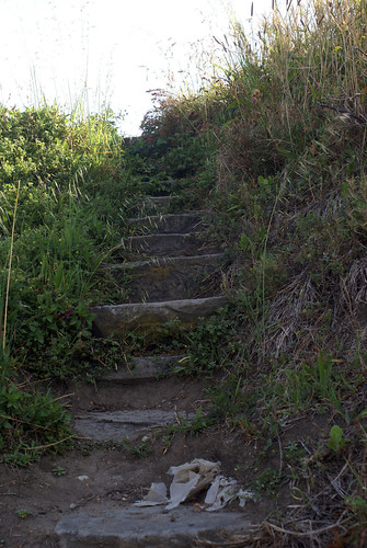
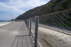
A few days into the residency now and I’ve managed to do a fair bit of research around Newcastle, carrying out a number of walks and working on some video pieces down on the beach. I came to Australia with ideas as regards work I wanted to carry out and that is going according to plan, but it’s always important when coming to something like this to leave room for work to develop as a consequence of initial and ongoing research. The first week was always going to be a time for gathering information, which I’ve done as a result of the walks around town, and through these, a number of areas which I couldn’t have known about before coming here have interested me. One of those areas is the story of Yi-ran-na-li, the Aboriginal name for cliffs near Newcastle beach. To see them surrounded (for reasons of safety) by a wire fence is a little sad to say the least, and the fact the sign describing the cliffs and the lack of respect they’ve received (‘it’s not too late to show the respect Yi-ran-na-li deserves‘) – contains spelling mistakes is far from encouraging. It’s a small thing, mis-spelling ‘the’ as ‘thre’ but it seems to speak volumes nevertheless. A work about this, entitled ‘Thre’ might therefore be on the cards.

The town of Newcastle is the world’s biggest exporter of coal, and the vast ships which come and take the coal away interest me a great deal. They look almost like a photoshopped image when you see them lined across the horizon, as if someone has done a cut and paste job with a single ship. Nobbys island – now attached to the mainland via the Macquarie Pier – was surveyed in 1797 by John Shortland who spotted coal seams and set to work having the island mined. The island itself was regarded by the Awabakal people as having been created in the time of the Dreaming by the great rainbow serpent as it pushed itself onto the land after dropping from the sky. It was also thought to be home to a giant Kangaroo, and again its rather sad to see it reduced from its original height of 62 metres to just 28.

Below is an image from the State Library of New South Wales showing Nobbys Island and Pier in 1820.

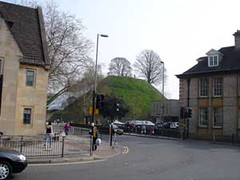
Compare this with how Nobbys Island looks today.

Nobbys Island

The importance placed on rocks by the Awabakal people finds a connection with the importance placed on coal by ‘modern man’. Seeing the ships come and take the coal away seems almost a metaphor for the ships which brought the convicts and took away something of the country’s ‘innocence’. Of course, one has to be careful not sound accusatory, rather, this is analogous to modern man’s destruction of the world for the sake of capital gain. Something is lost and the cliffs of Yi-ran-na-li remind us that sometimes we just need to listen.

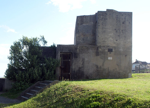
Listening was something carried out not far from Yi-ran-na-li, up on Shepherd’s Hill. The idea of the Radar as a metaphor for listening interests me, as well as the idea of looking out across the sea for approaching ships etc. The ships bringing the convicts, and the ships coming to take away the coal.

Whilst taking notes on one of my walks (walk 4) I wrote: The radar beeps of several crossings. This alludes to the crossings here which beep continuously until, with what sounds like a blast from a ray gun, you are given the go ahead to walk.

The idea of looking for the individual – a theme central to my work – becomes important here. In order to find those people, we sometimes have to listen to what the rocks have to tell us. Of course, for rocks we might substitute buildings, houses, roads, pathways etc. And as we walk amongst them, we are like a radar, a signal which looks for that which is invisible, and which returns – not a blip or a shadow on a screen – but what we might term an empathetic response.

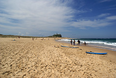
Whilst videoing on the beach, I became interested in the clouds, in the way they changed almost imperceptibly, looking – at a glance – as fixed as any sculpture, or in fact a photograph. Given the colour of the rain clouds, the contrast between dark grey and white, the connection with an early black and white photograph is strong – at least in my mind! Of course photographs don’t change, but the movement of clouds when studied over a period of time reminds us perhaps that the people photographed were part of a moving world, and that that world also had its clouds. Like the past, the world carried on beneath them, just as it does today.

Filed Under: A Line Drawn in Water, Artist in Residence Tagged With: A Line Drawn In Water, Artist in Residence, Australia, Everydayness, Family Hedges, Family History, Hedges, Lines, Stephen Hedges, Walks

Undermined

November 2, 2010 by Nicholas Hedges

During Walk No.4 I discovered a sign entitled ‘Undermined’ about the coal industry in Newcastle. Given the importance of coal to the area, I’ve reproduced the information below in its entirety.

‘Awabakal clans used Newcastle’s coal in their fires and ceremonies for millennia, and explain its origins in their ancient Dreaming stories. Europeans also sought this valuable substance, so when Lieutenant Shortland noted coal deposits here in 1797, shops were quickly dispatched to return quantities of coal to Sydney. In 1799 The Hunter exported a shipment of coal to Bengal, and Newcastle coal was later shipped to the Cape of Good Hope by the Anna Joseph.

During the early years of settlement, the Colonial Government declared Hunter River coal to be the property of the Crown and prohibited free individuals and companies from mining here. Convict gangs were obliged to work the coal seams and load the vessels.

In 1826 private enterprise was finally permitted to mine coal and the Australian Agricultural Company obtained the first lease. In 1831 the company sunk its initial shaft near the Anglican Cathedral and innumerable tunnels chasing the buried coal seams have since been excavated below Newcastle’s streets. The success of the Australian Agricultural Company soon attracted other companies and mining operations spread to the extensive coalfields of East Maitland in 1844.

Fast-loading steam cranes were installed at King’s Wharf in 1860. But the demand for coal still exceeded the loading capacity of the port so the Bullock Island mud flats were reclaimed and new coal loading wharves were constructed. In 1888, twelve hydraulic cranes were in position.

During the late nineteenth century, sailing vessels berthed two or three deep along the length of the Bullock Island dyke, creating a forest of masts, while hundreds of sailors of all nationalities flocked to the city of Newcastle on Saturday nights. Throughout the twentieth century, further developments in mining and loading saw Newcastle’s exports soar, and by 1907 coal shipments exceeded 4,500,000 tons.

The port of Newcastle has long been the economic and trade centre for the Hunter region. In the 1989-90 financial year Newcastle handled 68.2 million tonnes to become the world’s largest coal export port and Australia’s largest tonnage dock.’

Filed Under: A Line Drawn in Water, Artist in Residence Tagged With: A Line Drawn In Water, Artist in Residence, Australia, Everydayness, Family Hedges, Family History, Hedges, Lines, Stephen Hedges, Walks

Walks

October 31, 2010 by Nicholas Hedges

As part of my research during this residency, I’m undertaking a number of walks in and around Newcastle. During the walks, I write lists of observations; typically things which are seemingly insignificant or everday occurrences. Each walk is also recorded using GPS as are the number of steps using a pedometer.

The first two lists can be found via the links below:

Walk 1
www.nicholashedges.co.uk/lockup/walk1.htm

Walk 2
www.nicholashedges.co.uk/lockup/walk2.htm

Filed Under: Artist in Residence Tagged With: A Line Drawn In Water, Artist in Residence, Australia, Everydayness, Family Hedges, Family History, Hedges, Lines, Stephen Hedges, Walks

Shepherds Hill

October 31, 2010 by Nicholas Hedges

Whilst on my walk today, I took some time to explore the concrete ruins of what I discovered was the Shepherds Hill complex, described on a plaque fixed to one of the walls.

The text of the plaque is as follows: 

The Shepherds Hill complex is unique to in Australia for housing, during 1942, all three services at one time. A fortress observation post (army) coordinated the guns at Fort Wallace, Fort Scratchley and Park Battery. A Radar station (RAAF) assisted in locating air and seabourne targets. A port war signal station (Navy) monitored shipping movements to identify if friendly or enemy. A directing station (Army) coordinated the coastal searchlights which were used to illuminate seabourne targets. The army also took over nearby houses as well as King Edward Park, closing it to the public.

The empty concrete rooms, all stopped up with bars are strangely enigmatic. Full of detritus, graffiti and fragments of rusted metal like fossilised bones, they’re also full of lines, the movements of people busy at the time of the second world war.

The steps that lead nowhere lead one nonetheless back to a time when they had a purpose, when they weren’t incongruous but rather banal and a part of everyday activity.

As I looked around the ruins, casting my eyes like the sonic pulse of a radar, I could imagine the individuals who once worked there, picking them out like blips on a radar screen. And it was interesting, given what I wrote about yesterday, that this space had once been used for the purpose of listening, just a few hundred yards from Yi-ran-na-li, where people haven’t listened enough.

Filed Under: A Line Drawn in Water, Artist in Residence Tagged With: A Line Drawn In Water, Artist in Residence, Australia, Everydayness, Family Hedges, Family History, Hedges, Lines, Stephen Hedges, Walks

Yi-ran-na-li

October 30, 2010 by Nicholas Hedges

At the end of Nobbys beach can be found Nobbys Island. Once a rocky outcrop, the island was joined to the mainland through work carried out by convict gangs between 1818 and 1846. In 1855, the quarried summit of the island (the rock of which had been used to create the pier joining the island with the mainland) was cut down from 62 metres to his present height of 28 metres. A sign near the island explains how the local Aboriginal people, the Awabakal, believe Nobbys Island was created in the time of the Dreaming by the great rainbow serpent as it pushed itself onto the land after it had dropped from the sky into the island. To read how it was mined for coal (after being surveyed by Lieutenant John Shortland who surveyed the bluff during the 1790s) and then – being a danger to ships – reduced by almost a third in height, makes one feel sorry, especially in light of the beliefs of the Awabakal people.

The importance placed on rocks by Aboriginal people is also described near Newcastle beach, where a sign describes Yi-ran-na-li, the Aboriginal name for the cliff which, the sign tells us, is known by them as being a place of silence and respect. The cliff was – or rather is – a sacred place and the sign itself something of an apologia, the text of which is worth repeating here in full:

“In the 1880s, John McGill, an Awakbal man, also known as Biraban (Eaglehawk) told the missionary Reverend Lancelot Threlkeld the story of Yi-ran-na-li whilst passing beneath the cliff one day.

‘There is a sort of scared place near Newcastle on the sea-beach, beneath a high cliff named Yi-ran-na-li, it is said, that if any person speaks, the stones will fall  down upon them, from the high arched rocks above, the crumbling state of which is such as to render it extremely probable, that the mere concussion of air from the voice would cause the effect to take place.

I was walking beneath the projecting rock and called loudly to McGill , who with other blacks, were with me. He instantly beckoned me to be silent, at which I wondered, a few small stones fell down from the crumbling overshadowing cliff at that moment, and they urged me on.

When we had passed out the precincts of the fearful place, I asked what they meant by commanding my silence, and pushing on so quickly without speaking? This elicited the tradition of the place as a very fearful one, for if any one speaks whilst passing beneath the overhanging rocks, stones would invariably fall as we had just witnessed.’ (Threkeld in Gunson 1974:65)

The large rock fall in 2002 perhaps marked Yi-ran-na-li’s final stand. It was a rock so large that we couldn’t ignore it. The rock was a statement about our inability to live within the constraints and sensitivities of place. Despite the removal of the rock and the total reshaping of the cliff face to make it ‘safer’ we should not forget the cultural belief of the local Aboriginal people that this place was to be feared and respected.

The cliff speaks to us with a wisdom that is thousands of years old. McGill knew this cultural wisdom but we have failed to listen, and today we still have so much to learn about the many other aspects of an endemic sense of place and about the environment we live in.

It is not too late to show the respect that Yi-ran-na-li deserves.’

The photograph below, shows Yi-ran-na-li today:

I was struck by the last paragraph admitting to the country’s failings as regard its indigenous population and their ancient heritage (although this is in no way only an Australian problem: America, Europe, and in particular Britain have shown throughout history a blatant disregard for the culture of those people on whose countries it has claimed dominion). As regards Yi-ran-na-li, how can such respect be shown when, as the text also describes the rocks – like Nobbys Island – have been reshaped? Should the fallen rock have been removed? Would it not have been a good idea to leave it as a reminder of cultural ignorance and its consequences? It seems to me there is a strong correlation between failing to listen and speaking when we shouldn’t. Also, the fact the sign contained a few typos didn’t really help as regards the sincerity of its message. I’ve no doubt that it is sincere, but small things like spelling the ‘thre’ undermines its message nevertheless.

Filed Under: A Line Drawn in Water, Artist in Residence Tagged With: A Line Drawn In Water, Artist in Residence, Australia, Everydayness, Family Hedges, Family History, Hedges, Lines, Silence, Stephen Hedges, Walks

Day 8

April 13, 2007 by Nicholas Hedges

Having consulted two maps (one a Google map, the other David Loggan’s map of 1675), I finally planned a new route for my ‘walking work’ which is as follows:

Gloucester Green
Chain Alley
George Street
Worcester Street
Tidmarsh Lane
St. Thomas’ Street
Paradise Street
Castle Street
Bulwarks Lane
George Street
Gloucester Place
Gloucester Green

Below are some photographs of the route of the walk:

More photographs of this route can be seen on my Flickr pages. This isn’t an area I know that well – I’m not sure if I’ve ever walked the entire length of Paradise Street – and yet afterwards, when I looked at David Loggan’s map of 1675, it all seemed very familiar. I was surprised at how much was left after the upheaval of redevelopment, particularly when standing near St. George’s tower, near the junction of St. Thomas’ and Paradise Streets. Now, looking at John Gwynn’s surveys, I could make much more sense of the Oxford of 1772.

Filed Under: Artist in Residence, Lists Tagged With: Artist in Residence, Listmaking, Lists, Residue, Walks

  • « Previous Page
  • 1
  • 2

© Nicholas Hedges 2024

  • Facebook
  • Instagram
  • Twitter
  • YouTube

Copyright © 2025 · Outreach Pro on Genesis Framework · WordPress · Log in